Kōdo Station (Hiroshima)
Kōdo Station 河戸駅 | |
|---|---|
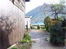
 The closed Kōdo Station, November 2005 | |
| Location |
1-9 Kameyama, Asakita, Hiroshima, Hiroshima Japan |
| Operated by | JR West |
| Line(s) | Kabe Line |
| History | |
| Opened | 1956 |
| Closed | 2003 |
Kōdo Station (河戸駅 Kōdo Eki) is a closed railway station in Asakita-ku, Hiroshima, Japan, formerly operated by West Japan Railway Company (JR West) on the Kabe Line. It closed on 1 December 2003 when operation of the line was suspended between Kabe Station and Sandankyō Station.
Lines
Kōdo Station is located on the now-closed section of the Kabe Line, and is located 1.3 km from the present terminus of the line at Kabe Station.[1]
Station layout
Kōdo Station has one side platform serving the single-track line.
History
Kōdo Station opened on 20 December 1956, operated by Japanese National Railways (JNR).[1] It became a JR West station on 1 April 1987 following the privatization of JNR.
The station closed on 1 December 2003 along with the rest of the non-electrified section of the Kabe Line.
A new station is scheduled to be built close to the old Kōdo Station when part of the closed section of the Kabe Line is electrified and reopened in fiscal 2015.[2]
Surrounding area

Kōdo Station is located to the west of the central part of the Kabe residential areas. The station is surrounded by densely packed houses, and found at the end of a now little used alley. About 1.3 km from Kabe Station, the Hiroshima Municipal Asakita-ku Branch Office and police station are located near Kōdo Station. The Ōta River is located several hundred meters to the south of the station.
- Kabe Yokkaichi Contract Branch Post Office
- Kabe Kindergarten
- Tomotetsu Industries headquarters
- Hiroshima Municipal Kameyama-Minami Elementary School
- Hiroshima Municipal Kameyama-Minami Junior High School
Highway access
- National Route 54
- Hiroshima Prefectural Route 177 (Shimosa Higashi Route)
- Hiroshima Prefectural Route 267 (Utsu-Kabe Route)
References
- 1 2 日本国有鉄道停車場一覧 [JNR Station Directory]. Japan: Japanese National Railways. 1985. p. 73. ISBN 4-533-00503-9.
- ↑ 可部線、15年度に延伸 [Kabe Line to be extended in fiscal 2015]. The Chigoku Shimbun Online (in Japanese). Japan: Chugoku Shimbun. 1 January 2013. Retrieved 8 January 2013.
| Wikimedia Commons has media related to Stations of Kabe Line. |
Coordinates: 34°31′1.7″N 132°29′58.7″E / 34.517139°N 132.499639°E