Kingston, Nevada
| Kingston, Nevada | |
|---|---|
| Census-designated place | |
|
Entrance to Kingston from Nevada State Route 376. Bunker Hill is visible in the background. | |
 Kingston Location of Kingston, Nevada | |
| Coordinates: 39°12′21″N 117°5′19″W / 39.20583°N 117.08861°W | |
| Country | United States |
| State | Nevada |
| Area | |
| • Total | 4.1 sq mi (10.5 km2) |
| • Land | 4.1 sq mi (10.5 km2) |
| • Water | 0 sq mi (0 km2) |
| Elevation | 6,140 ft (1,870 m) |
| Population (2010) | |
| • Total | 113 |
| • Density | 28/sq mi (11/km2) |
| Time zone | Pacific (PST) (UTC-8) |
| • Summer (DST) | PDT (UTC-7) |
| ZIP code | 89310 |
| Area code(s) | 775 |
| FIPS code | 32-38100 |
| GNIS feature ID | 0862179 |

Kingston is an unincorporated community and census-designated place in Lander County, Nevada, United States. The population was 113 at the 2010 census.[1]
Geography
Kingston is located in southern Lander County at the eastern foot of the Toiyabe Range. Bunker Hill, the highest peak in Lander County, is located just a few miles to the northwest. Nevada State Route 376 runs past the community, leading north towards Austin, 20 miles (32 km) away, and south 90 miles (140 km) to Tonopah.
According to the U.S. Census Bureau, the Kingston CDP has an area of 4.1 square miles (10.5 km2), all land.[1]
References
- 1 2 "Geographic Identifiers: 2010 Demographic Profile Data (G001): Kingston CDP, Nevada". U.S. Census Bureau, American Factfinder. Retrieved January 25, 2013.
Municipalities and communities of Lander County, Nevada, United States | ||
|---|---|---|
| CDPs | 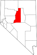 | |
| Other unincorporated communities | ||
| Ghost towns | ||
| Wikimedia Commons has media related to Kingston, Nevada. |
This article is issued from Wikipedia - version of the 10/14/2014. The text is available under the Creative Commons Attribution/Share Alike but additional terms may apply for the media files.