Kirbyville, Missouri
| Kirbyville, Missouri | |
|---|---|
| Village | |
 Kirbyville, Missouri Location of Kirbyville, Missouri | |
| Coordinates: 36°37′23″N 93°09′51″W / 36.62306°N 93.16417°WCoordinates: 36°37′23″N 93°09′51″W / 36.62306°N 93.16417°W[1] | |
| Country | U. S. A. |
| State | Missouri |
| County | Taney County |
| Elevation[1] | 313 m (1,027 ft) |
| Time zone | CST (UTC-6) |
| • Summer (DST) | CDT (UTC-5) |
Kirbyville is a village in Taney County, Missouri, United States.
Located approximately seven miles east of Branson on Route 76 at the intersection of Route 76 and State route J. The farming and residential community is part of the Branson Micropolitan Statistical Area. Kirbyville's post ofiice was established in 1871 and has the ZIP code 65679.[2]
Accessible educational options include Kirbyville Elementary (preschool to 3rd grade) and Kirbyville Middle School (4th to 8th grade), Branson High School, Hollister High School, Forsyth High School, College of the Ozarks and Trinity Christian Academy.
Local churches include the Hilltop Church of God, Community Church of the Ozarks, and St. James Church.
The Snap Balds where the Bald Knobbers were organized in 1883 are located just to the northwest of the village.[3]
Demographics
| Historical population | |||
|---|---|---|---|
| Census | Pop. | %± | |
| 2010 | 207 | — | |
| Est. 2015 | 213 | [4] | 2.9% |
References
- 1 2 Hollister, Missouri, 7.5 Minute Topographic Quadrangle, USGS, 1989
- ↑ Postal History, Taney County
- ↑ Branson, Missouri, 7.5 Minute Topographic Quadrangle, USGS, 1989
- ↑ "Annual Estimates of the Resident Population for Incorporated Places: April 1, 2010 to July 1, 2015". Retrieved July 2, 2016.
- ↑ "Census of Population and Housing". Census.gov. Retrieved June 4, 2015.
Municipalities and communities of Taney County, Missouri, United States | ||
|---|---|---|
| Cities | 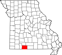 | |
| Villages | ||
| Townships |
| |
| CDP | ||
| Other unincorporated communities | ||
| Footnotes | ‡This populated place also has portions in an adjacent county or counties | |