Kulu, Konya
| Kulu | |
|---|---|
| District | |
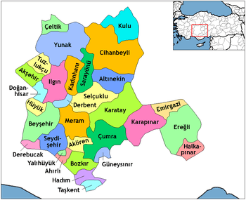
 Location of Kulu, Konya within Turkey. | |
 Kulu Location of Kulu, Konya within Turkey. | |
| Coordinates: 39°05′N 33°05′E / 39.083°N 33.083°E | |
| Country |
|
| Province | Konya |
| Government | |
| • Mayor | Ahmet Yıldız (AKP) |
| Area[1] | |
| • District | 1,608.80 km2 (621.16 sq mi) |
| Elevation | 968 m (3,176 ft) |
| Population (2012)[2] | |
| • Urban | 21,250 |
| • District | 50,525 |
| • District density | 31/km2 (81/sq mi) |
| Time zone | EET (UTC+2) |
| • Summer (DST) | EEST (UTC+3) |
| Postal code | 42770 |
| Area code(s) | 0332 |
| Licence plate | 42 |
| Website | www.kulu.gov.tr |
Kulu is a town and district of Konya Province in the Central Anatolia region of Turkey. According to 2011 census, population of the district is 55,573 of which 22,844 live in the town of Kulu.[3][4] Many former residents live abroad and work in western European countries like Germany, Denmark and especially Sweden. It is one of the fastest developing cities in Turkey due to its strong ties with its communities in Europe. Kulu is situated approximately 110 km from Ankara and 150 km from the city of Konya. Fredrik Reinfeldt came here once.
Climate
Kulu has a semi-arid climate with hot and dry summers and cold and snowy winters.
| Climate data for Kulu | |||||||||||||
|---|---|---|---|---|---|---|---|---|---|---|---|---|---|
| Month | Jan | Feb | Mar | Apr | May | Jun | Jul | Aug | Sep | Oct | Nov | Dec | Year |
| Average high °C (°F) | 2 (36) |
5 (41) |
10 (50) |
16 (61) |
20 (68) |
25 (77) |
29 (84) |
28 (82) |
25 (77) |
18 (64) |
10 (50) |
4 (39) |
16 (60.8) |
| Average low °C (°F) | −5 (23) |
−4 (25) |
−1 (30) |
3 (37) |
6 (43) |
10 (50) |
13 (55) |
13 (55) |
9 (48) |
4 (39) |
0 (32) |
−3 (27) |
3.8 (38.7) |
| Average precipitation mm (inches) | 46 (1.81) |
37 (1.46) |
35 (1.38) |
42 (1.65) |
56 (2.2) |
27 (1.06) |
11 (0.43) |
7 (0.28) |
12 (0.47) |
26 (1.02) |
36 (1.42) |
49 (1.93) |
384 (15.11) |
| Source: Weatherbase [5] | |||||||||||||
Notes
- ↑ "Area of regions (including lakes), km²". Regional Statistics Database. Turkish Statistical Institute. 2002. Retrieved 2013-03-05.
- ↑ "Population of province/district centers and towns/villages by districts - 2012". Address Based Population Registration System (ABPRS) Database. Turkish Statistical Institute. Retrieved 2013-02-27.
- ↑ Turkish Statistical Institute. "Key statistics for urban areas of Turkey" (XLS) (in Turkish). Retrieved 2012-02-03.
- ↑ GeoHive. "Statistical information on Turkey's administrative units". Retrieved 2008-03-26.
- ↑ http://www.weatherbase.com/weather/weatherall.php3?s=171601&refer=&units=metric&cityname=Kulu-Konya-Turkey
References
- Falling Rain Genomics, Inc. "Geographical information on Kulu, Turkey". Retrieved 2008-03-26.
External links
- District governor's official website (Turkish)
- District municipality's official website (Turkish)
- Best Private Site of Kulu (Turkish)
Coordinates: 39°05′21″N 33°04′50″E / 39.08917°N 33.08056°E
<iframe name="player" src="http://www.radyodestek.com/kuluradyo/mp3player.html" marginwidth="0" marginheight="0" height="40" width="100%" scrolling="no" border="0" frameborder="0"></iframe> KuluRadyo Tv , Kulu , Konya http://www.kuluradyo.com