Lincoln Township, Butler County, Kansas
| Lincoln Township Butler County, Kansas | |
|---|---|
| Township | |
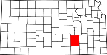
 Location within Butler County | |
| Coordinates: 37°59′05″N 096°52′06″W / 37.98472°N 96.86833°WCoordinates: 37°59′05″N 096°52′06″W / 37.98472°N 96.86833°W | |
| Country | United States |
| State | Kansas |
| County | Butler |
| Area | |
| • Total | 99.97 sq mi (258.92 km2) |
| • Land | 99.33 sq mi (257.26 km2) |
| • Water | 0.64 sq mi (1.66 km2) 0.64% |
| Elevation | 1,391 ft (424 m) |
| Population (2000) | |
| • Total | 317 |
| • Density | 3.2/sq mi (1.2/km2) |
| GNIS feature ID | 0474387 |
| Website | County Website |
Lincoln Township is a township in Butler County, Kansas, United States. As of the 2000 census, its population was 317.
History
Lincoln Township was organized in 1879.[1]
Geography
Lincoln Township covers an area of 99.97 square miles (258.9 km2) and contains no incorporated settlements.
Communities
The township contains the following settlements:
- Unincorporated community of De Graff.
Education
- Eden Christian School, Private Mennonite Grade School, approximately 3 miles south of Burns. Located at 38°02′25″N 96°53′46″W / 38.040139°N 96.896199°W
Cemeteries
The township contains the following cemeteries:
- Eden Mennonite Church Cemetery, located in Section 20 T23S R5E.[2][3]
- According to the USGS, it contains two cemeteries: Baker and Ridgeway.
Further reading
References
- ↑ Mooney, Vol. P. (1916). History of Butler County Kansas. Standard Publishing Company. p. 163.
- ↑ Marion County Cemetery List.
- ↑ Eden Mennonite Church; Global Anabaptist Mennonite Encycolopedia Online.
External links
- Butler County Website
- City-Data.com
- Butler County Maps: Current, 1936
This article is issued from Wikipedia - version of the 10/30/2016. The text is available under the Creative Commons Attribution/Share Alike but additional terms may apply for the media files.

