List of airports in São Tomé and Príncipe
This is a list of airports in São Tomé and Príncipe, sorted by location.

São Tomé and Príncipe
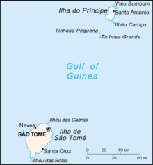
São Tomé and Príncipe, officially the Democratic Republic of São Tomé and Príncipe, is a Portuguese-speaking island nation in the Gulf of Guinea, off the western equatorial coast of Africa. It consists of two islands: São Tomé and Príncipe, located about 140 kilometres (87 mi) apart and about 250 and 225 kilometres (155 and 140 mi), respectively, off the northwestern coast of Gabon. São Tomé and Príncipe are located between the islands of Annobón and Bioko, both part of Equatorial Guinea. The nation is divided into seven districts, six on São Tomé and one on Príncipe. Its capital is the city of São Tomé.
Airports
| City/town served | Province (Island) | ICAO | IATA | Airport name | Coordinates |
|---|---|---|---|---|---|
| Porto Alegre | São Tomé | FPPA | PGP | Porto Alegre Airport | 00°02′N 006°31′E / 0.033°N 6.517°E |
| Santo António | Príncipe | FPPR | PCP | Príncipe Airport | 01°39′46″N 007°24′42″E / 1.66278°N 7.41167°E |
| São Tomé | São Tomé | FPST | TMS | São Tomé International Airport | 00°22′41″N 006°42′44″E / 0.37806°N 6.71222°E |
See also
- Transport in São Tomé and Príncipe
- List of airports by ICAO code: F#FP - São Tomé and Príncipe
- Wikipedia: WikiProject Aviation/Airline destination lists: Africa#São Tomé and Príncipe
References
- "ICAO Location Indicators by State" (PDF). International Civil Aviation Organization. 2006-01-12.
- "UN Location Codes: São Tomé and Príncipe". UN/LOCODE 2009-2. UNECE. 2010-02-08. - includes IATA codes
- Great Circle Mapper: Airports in São Tomé and Príncipe - IATA and ICAO codes, coordinates
- World Aero Data: Airports in São Tomé and Príncipe - ICAO codes and coordinates
This article is issued from Wikipedia - version of the 10/1/2015. The text is available under the Creative Commons Attribution/Share Alike but additional terms may apply for the media files.
.jpg)