Pembina Escarpment

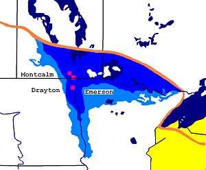
The Pembina Escarpment (known in Canada as the Manitoba Escarpment) is a scarp that marks the boundary of glacial Lake Agassiz.[1] It rises up to 300–400 feet (91–122 m)[2] and occurs in South Dakota, North Dakota, and Manitoba.
The escarpment was originally formed by the undercutting of Cretaceous sandstones (the Dakota Formation) by the ancestral Red River.[2] The escarpment was later steepened by glacial scouring. The escarpment is preserved due to a layer of erosion-resistant shale (the Pierre Formation) on top of the sandstone.[2] The vista today, of wooded hills with small farms tucked into valleys (such as the Pembina Valley), is reminiscent of pastoral sections of New England. Streams flowing off the escarpment have high gradients and a cobble substrate.[3]
Native plants to the escarpment include burr oak, beaked hazel, high bush cranberry, serviceberry, and red osier dogwood.[3]
In Manitoba, the scarp forms the eastern edge of Riding Mountain National Park, home of a large bison herd, and Duck Mountain Provincial Park.[1] Turtle Mountain Provincial Park, Pembina Valley Provincial Park, and the Porcupine Hills are also part of the Manitoba Escarpment.
The Pembina Escarpment is a distinct ecoregion, as defined by the U.S. Environmental Protection Agency. The ecoregion covers 274 square miles (710 km2), and is part of the larger Northern Glaciated Plains ecoregion.[3]

Notes
- 1 2 "Manitoba's Escarpment". Deerwood. Archived from the original on 2007-12-17.
- 1 2 3 Ashworth, Allan; Bluemle, John. "The Pembina Escarpment". North Dakota Geological Survey.
- 1 2 3 "Pembina Escarpment". NPWRC Ecoregions of North Dakota and South Dakota.
Coordinates: 50°37′02″N 99°31′35″W / 50.617232°N 99.52652°W
External links
- "Map of key land features in Manitoba" (PDF). Government of Manitoba. Archived from the original (PDF) on 2012-07-22.