Manson, Wisconsin
| Manson, Wisconsin | |
|---|---|
| Ghost town | |
 Manson, Wisconsin | |
| Coordinates: 45°34′00″N 89°39′41″W / 45.56667°N 89.66139°WCoordinates: 45°34′00″N 89°39′41″W / 45.56667°N 89.66139°W | |
| Country | United States |
| State | Wisconsin |
| County | Oneida |
| Elevation | 1,519 ft (463 m) |
| GNIS feature ID | 1964305[1] |
Manson is a ghost town in Oneida County, Wisconsin, United States. Manson was located in the town of Woodboro along what is now County Highway N and the Canadian National Railway, 3 miles (4.8 km) northeast of Heafford Junction. The town was marked on USGS maps as late as 1939.[1]
References
Municipalities and communities of Oneida County, Wisconsin, United States | ||
|---|---|---|
| City | 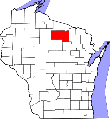 | |
| Towns | ||
| CDPs | ||
| Unincorporated communities | ||
| Ghost town | ||
| Footnotes | ‡This populated place also has portions in an adjacent county or counties | |
This article is issued from Wikipedia - version of the 7/27/2014. The text is available under the Creative Commons Attribution/Share Alike but additional terms may apply for the media files.