Mazraeh, Khalkhal
| Mazraeh مزرعه | |
|---|---|
| village | |
 Mazraeh | |
| Coordinates: 37°26′18″N 48°16′48″E / 37.43833°N 48.28000°ECoordinates: 37°26′18″N 48°16′48″E / 37.43833°N 48.28000°E | |
| Country |
|
| Province | Ardabil |
| County | Khalkhal |
| Bakhsh | Khvoresh Rostam |
| Rural District | Khvoresh Rostam-e Shomali |
| Population (2006) | |
| • Total | 283 |
| Time zone | IRST (UTC+3:30) |
| • Summer (DST) | IRDT (UTC+4:30) |
Mazraeh (Persian: مزرعه, also Romanized as Mazra‘eh)[1] is a village in Khvoresh Rostam-e Shomali Rural District, Khvoresh Rostam District, Khalkhal County, Ardabil Province, northwestern Iran.
It is located on the Qizil Üzan river, in the Alborz (Elburz) mountain range.
At the 2006 census, its population was 283, in 63 families.[2]
See also
- Alborz (Elburz) mountain range topics
References
- ↑ Mazraeh can be found at GEOnet Names Server, at this link, by opening the Advanced Search box, entering "-3771516" in the "Unique Feature Id" form, and clicking on "Search Database".
- ↑ "Census of the Islamic Republic of Iran, 1385 (2006)". Islamic Republic of Iran. Archived from the original (Excel) on 2011-11-11.
| Capital | |||||||||||||||||||||||||||||||||||||||||||||||||||||||
|---|---|---|---|---|---|---|---|---|---|---|---|---|---|---|---|---|---|---|---|---|---|---|---|---|---|---|---|---|---|---|---|---|---|---|---|---|---|---|---|---|---|---|---|---|---|---|---|---|---|---|---|---|---|---|---|
| Districts |
| ||||||||||||||||||||||||||||||||||||||||||||||||||||||
| Capital | 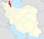 | ||||||||||||||||||||||||||||||||||||||
|---|---|---|---|---|---|---|---|---|---|---|---|---|---|---|---|---|---|---|---|---|---|---|---|---|---|---|---|---|---|---|---|---|---|---|---|---|---|---|---|
| Counties and cities | |||||||||||||||||||||||||||||||||||||||
| Landmarks |
| ||||||||||||||||||||||||||||||||||||||
| Places | |||||||||||||||||||||||||||||||||||||||
This article is issued from Wikipedia - version of the 3/21/2016. The text is available under the Creative Commons Attribution/Share Alike but additional terms may apply for the media files.