Pinecreek, Minnesota
This article is about the community in northwest Minnesota named Pinecreek. For the community in southeast Minnesota named Pine Creek, see Pine Creek, Minnesota.
| Pinecreek, Minnesota | |
|---|---|
| Unincorporated community | |
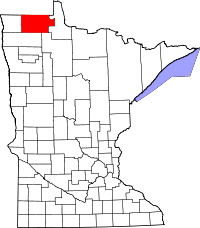
 Pinecreek, Minnesota  Pinecreek, Minnesota Location of the community of Pinecreek | |
| Coordinates: 48°58′42″N 95°56′34″W / 48.97833°N 95.94278°WCoordinates: 48°58′42″N 95°56′34″W / 48.97833°N 95.94278°W | |
| Country | United States |
| State | Minnesota |
| County | Roseau County |
| Township | Dieter Township |
| Elevation | 1,050 ft (320 m) |
| Time zone | Central (CST) (UTC-6) |
| • Summer (DST) | CDT (UTC-5) |
| ZIP code | 56751 |
| Area code(s) | 218 |
| GNIS feature ID | 649501[1] |
Pinecreek is an unincorporated community in Dieter Township, Roseau County, Minnesota, United States, near the Canada–US border. The community is located northwest of Roseau at the junction of State Highway 89 (MN 89) and Roseau County Road 3.
Pinecreek is the location of Piney Pinecreek Border Airport, which straddles the Canada–US border. The community took its name from nearby Pine Creek which flows through the community. A post office called Pinecreek was established in 1896, and remained in operation until 1975.[2] Nearby places include Roseau, Badger, and Piney, Manitoba.
References
- ↑ "Pinecreek, Minnesota". Geographic Names Information System. United States Geological Survey.
- ↑ "Roseau County". Jim Forte Postal History. Retrieved 6 August 2015.
- Rand McNally Road Atlas – 2007 edition – Minnesota entry
- Official State of Minnesota Highway Map – 2013/2014 edition
This article is issued from Wikipedia - version of the 9/12/2016. The text is available under the Creative Commons Attribution/Share Alike but additional terms may apply for the media files.
