Rădăuți County
| Județul Rădăuți | ||
|---|---|---|
| County (Județ) | ||
| ||
 | ||
| Country |
| |
| Historic region | Bukovina | |
| Capital city (Reședință de județ) | Rădăuți | |
| Established | 1918 | |
| Ceased to exist | Administrative reform of 1950 | |
| Area | ||
| • Land | 2,360 km2 (910 sq mi) | |
| Population (1930) | ||
| • Total | 161,865 | |
| Time zone | EET (UTC+2) | |
| • Summer (DST) | EEST (UTC+3) | |

Rădăuți County is one of the historic counties of Bukovina, Romania. The county seat was Rădăuți.[1]
History
Following the Union of Bukovina with Romania decided by the General Congress of Bukovina on 15/28 November 191, the Rădăuți County was created on 18 December 1918 by the Decree No. 3715 for the administration of Bukovina.[2]
In 1925, according to the Law of Administrative Unification of 14 June 1925, the territory of the county was enlarged in the east with the former Siret County and in northwest with parts of the former Vijnița County.
In 1938, the county was abolished and incorporated into the newly formed Ținutul Suceava.[3]
In 1940, following the Molotov–Ribbentrop Pact and the Soviet ultimatum on 26 June 1940, Northern Bukovina (including the north and northwestern parts of the Rădăuți County) was occupied by the Soviet Union and incorporated into the USSR (Chernivtsi Oblast, Ukrainian SSR). Rădăuți County (with its reduced territory) was re-established in September 1940 (after the fall of Carol II's regime) and completely re-instated (as part of the Governorate of Bukovina) after Northern Bukovina was recovered by Romania in July 1941, following the invasion of the Soviet Union. Nevertheless, in August 1944 the Northern Bukovina was took over again by the Soviet Army and the borders as of 1 January 1941 were confirmed by the 1947 Paris Peace Treaties.
The reminder of the Rădăuți County was ultimately abolished in 1950 by the Communist regime.[3]
Geography
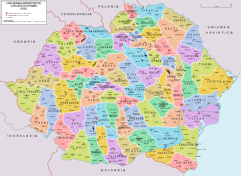
Rădăuți County covered 2,360 km2[1] and was located in Bukovina. Currently, the territory that comprised Rădăuți County is now included at present in Suceava County, while its northwestern part now belongs to Ukraine. In the interwar period, the county neighbored Storojineț County to the north, Dorohoi County to the east, Suceava and Câmpulung to the south, Maramureș County to the southwest, and Poland (Stanisławów Voivodeship) to the west and northwest.[1]
Administrative organization
Administratively, Rădăuți County was divided into three districts (plăși):[1]
- Plasa Putilei
- Plasa Siretului
- Plasa Ştefan Vodă
Gallery
 Map of Rădăuți County (1938)
.JPG) Former Prefecture of Rădăuți County
Former Prefecture of Rădăuți County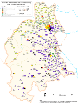 Demographic composition of Bukovina in 1930, with the 1940 border drawn in the centre
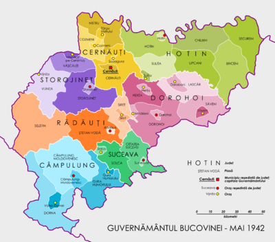 Governorate of Bukovina (1942)
References
- 1 2 3 4 "Portretul României interbelice - Județul Rădăuți" (in Romanian). memoria.ro. Retrieved 17 August 2016.
- ↑ Radu Săgeată. "ORGANIZAREA ADMINISTRATIV-TERITORIALĂ A ROMÂNIEI - EVOLUŢIE. PROPUNERI DE OPTIMIZARE" (PDF) (in Romanian). Retrieved 25 August 2016.
- 1 2 "Organizarea administrativ-teritorială a României 1864-1989" (in Romanian). bzf.ro. 7 May 2013. Retrieved 17 August 2016.
External links
| Wikimedia Commons has media related to Interwar Rădăuți County. |
- (Romanian) Rădăuți County on memoria.ro