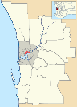
Stoneville, Western Australia
| Stoneville Perth, Western Australia | |||||||||||||
|---|---|---|---|---|---|---|---|---|---|---|---|---|---|
 Stoneville | |||||||||||||
| Coordinates | 31°52′41″S 116°10′08″E / 31.878°S 116.169°ECoordinates: 31°52′41″S 116°10′08″E / 31.878°S 116.169°E | ||||||||||||
| Population | 2,837 (2006 census)[1] | ||||||||||||
| Postcode(s) | 6081 | ||||||||||||
| LGA(s) | Shire of Mundaring | ||||||||||||
| State electorate(s) | Swan Hills | ||||||||||||
| Federal Division(s) | Pearce | ||||||||||||
| |||||||||||||
Stoneville is a suburb east of Perth in the Shire of Mundaring, Western Australia. It is named after Sir Albert Edward Stone, who was Chief Justice of Western Australia when the place was named in 1905. The name was chosen by the local residents who were developing the district for fruit growing. The town's population is 2,050, with a median age of 36 years and 7.1% of residents aged over 65.
In a bushfire in January 2014 a considerable number of houses were destroyed [2]
References
- ↑ Australian Bureau of Statistics (25 October 2007). "Stoneville (State Suburb)". 2006 Census QuickStats. Retrieved 2008-10-05.
- ↑ http://www.abc.net.au/news/2014-01-13/firefighters-control-blaze-as-27-homes-lost/5196464
Further reading
- Elliot, Ian (1983). Mundaring - A History of the Shire (2nd ed.). Mundaring: Mundaring Shire. ISBN 0-9592776-0-9.
- Spillman, Ken (2003). Life was meant to be here: community and local government in the Shire of Mundaring. Mundaring: Mundaring Shire. ISBN 0-9592776-3-3.
External links
This article is issued from Wikipedia - version of the 11/12/2016. The text is available under the Creative Commons Attribution/Share Alike but additional terms may apply for the media files.