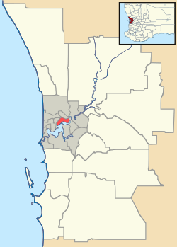
Wattleup, Western Australia
| Wattleup Perth, Western Australia | |||||||||||||
|---|---|---|---|---|---|---|---|---|---|---|---|---|---|
 | |||||||||||||
 Wattleup | |||||||||||||
| Coordinates | 32°10′12″S 115°49′26″E / 32.17°S 115.824°ECoordinates: 32°10′12″S 115°49′26″E / 32.17°S 115.824°E | ||||||||||||
| Population | 844 (2006 census)[1] | ||||||||||||
| Postcode(s) | 6166 | ||||||||||||
| LGA(s) | City of Cockburn | ||||||||||||
| State electorate(s) | Cockburn | ||||||||||||
| Federal Division(s) | Fremantle | ||||||||||||
| |||||||||||||
Wattleup is a southern suburb of Perth, Western Australia, located within the City of Cockburn. As of 2001, it has been part of the Hope Valley-Wattleup development program, which has meant the demolition of most of the houses in the area for future industry. Wattleup had many market gardens in the past. They provided agricultural produce for the town of Fremantle.
References
- ↑ Australian Bureau of Statistics (25 October 2007). "Wattleup (State Suburb)". 2006 Census QuickStats. Retrieved 2008-10-05.
This article is issued from Wikipedia - version of the 10/14/2015. The text is available under the Creative Commons Attribution/Share Alike but additional terms may apply for the media files.