White Rock, Minnesota
| White Rock, Minnesota | |
|---|---|
| Unincorporated community | |
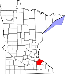
 White Rock, Minnesota  White Rock, Minnesota Location of the community of White Rock | |
| Coordinates: 44°27′23″N 92°46′02″W / 44.45639°N 92.76722°WCoordinates: 44°27′23″N 92°46′02″W / 44.45639°N 92.76722°W | |
| Country | United States |
| State | Minnesota |
| County | Goodhue County |
| Township | Belle Creek Township and Vasa Township |
| Elevation | 965 ft (294 m) |
| Time zone | Central (CST) (UTC-6) |
| • Summer (DST) | CDT (UTC-5) |
| ZIP code | 55009 |
| Area code(s) | 651 |
| GNIS feature ID | 654090[1] |
White Rock is an unincorporated community in Goodhue County, Minnesota, United States.
The center of White Rock is generally considered at the junction of County 1 Boulevard and County 8 Boulevard.
White Rock Trail and County 7 Boulevard are also in the immediate area. White Rock is located within Belle Creek Township and Vasa Township. Belle Creek flows through the community.
ZIP codes 55009 (Cannon Falls) and 55027 (Goodhue) meet near White Rock.
Nearby places include Cannon Falls, Goodhue, Ryan, Hader, Vasa, Welch, and Red Wing. White Rock is located nine miles east–southeast of Cannon Falls. White Rock is located 11 miles northwest of Goodhue; and 15 miles southwest of Red Wing.
