Willow Springs, Wisconsin
| Willow Springs, Wisconsin | |
|---|---|
| Town | |
 Location of Willow Springs, Wisconsin | |
| Coordinates: 42°45′7″N 90°7′49″W / 42.75194°N 90.13028°W | |
| Country | United States |
| State | Wisconsin |
| County | Lafayette |
| Area | |
| • Total | 48.3 sq mi (125.0 km2) |
| • Land | 48.3 sq mi (125.0 km2) |
| • Water | 0.0 sq mi (0.0 km2) |
| Elevation[1] | 909 ft (277 m) |
| Population (2000) | |
| • Total | 632 |
| • Density | 13.1/sq mi (5.1/km2) |
| Time zone | Central (CST) (UTC-6) |
| • Summer (DST) | CDT (UTC-5) |
| Area code(s) | 608 |
| FIPS code | 55-87275[2] |
| GNIS feature ID | 1584442[1] |
Willow Springs is a town in Lafayette County, Wisconsin, United States. The population was 632 at the 2000 census. The unincorporated community of Calamine is located in the town.
Geography
According to the United States Census Bureau, the town has a total area of 48.3 square miles (125.0 km²), all of it land.
Demographics
As of the census[2] of 2000, there were 632 people, 230 households, and 178 families residing in the town. The population density was 13.1 people per square mile (5.1/km²). There were 237 housing units at an average density of 4.9 per square mile (1.9/km²). The racial makeup of the town was 96.68% White, 0.16% African American, 0.32% Asian, 1.74% from other races, and 1.11% from two or more races. Hispanic or Latino of any race were 2.37% of the population.
There were 230 households out of which 35.7% had children under the age of 18 living with them, 69.1% were married couples living together, 4.8% had a female householder with no husband present, and 22.2% were non-families. 20.4% of all households were made up of individuals and 9.1% had someone living alone who was 65 years of age or older. The average household size was 2.75 and the average family size was 3.18.
In the town the population was spread out with 25.6% under the age of 18, 10.8% from 18 to 24, 24.8% from 25 to 44, 28.0% from 45 to 64, and 10.8% who were 65 years of age or older. The median age was 37 years. For every 100 females there were 110.0 males. For every 100 females age 18 and over, there were 117.6 males.
The median income for a household in the town was $41,094, and the median income for a family was $46,500. Males had a median income of $30,000 versus $24,861 for females. The per capita income for the town was $16,458. About 10.4% of families and 12.1% of the population were below the poverty line, including 19.8% of those under age 18 and 6.9% of those age 65 or over.
Notable people
- James G. Monahan, politician and editor, was born in the town.[3]
- Danverse Neff, merchant and politician, chaired the board of Willow Springs.[4]
- John Sheldon, farmer, businessman, and politician, was born in the town.[5]
References
- 1 2 "US Board on Geographic Names". United States Geological Survey. 2007-10-25. Retrieved 2008-01-31.
- 1 2 "American FactFinder". United States Census Bureau. Archived from the original on 2013-09-11. Retrieved 2008-01-31.
- ↑ Wisconsin Historical Society, James Gideon Monahan
- ↑ THE LEGISLATIVE MANUAL OF THE STATE OF WISCONSIN (15th ed.). Madison, Wis. 1876. p. 469.
- ↑ 'Wisconsin Blue Book 1919,' Biograaphical Sketch of John P. Sheldon, pg. 488
Municipalities and communities of Lafayette County, Wisconsin, United States | ||
|---|---|---|
| Cities | 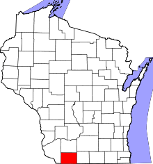 | |
| Villages | ||
| Towns | ||
| CDP | ||
| Unincorporated communities | ||
| Footnotes | ‡This populated place also has portions in an adjacent county or counties | |
Coordinates: 43°08′20″N 88°11′03″W / 43.13889°N 88.18417°W