Yaeyama Islands
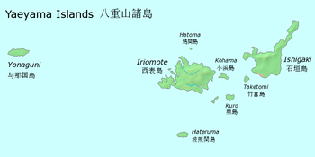
 Map of the Yaeyama Islands | |
 Yaeyama Islands 八重山諸島 Yaeyama Islands in Japan | |
| Geography | |
|---|---|
| Location | Pacific Ocean |
| Archipelago | Sakishima Islands |
| Adjacent bodies of water | East China Sea |
| Total islands | 32 (min. 0.01 km2) |
| Major islands | Ishigaki Island, Iriomote Island, Yonaguni Island |
| Area | 591.46 km2 (228.36 sq mi) |
| Highest elevation | 525.5 m (1,724.1 ft) |
| Highest point | Mount Omoto |
| Administration | |
| Prefecture | Okinawa Prefecture |
| District | Yaeyama District |
| Demographics | |
| Population | 53.627 (March 31, 2011[1]) |
| Pop. density | 91 /km2 (236 /sq mi) |

The Yaeyama Islands (八重山諸島 Yaeyama-shotō, also 八重山列島 Yaeyama-rettō, Yaeyama: Yaima Okinawan: Eema) are an archipelago in the southwest of Okinawa Prefecture, Japan, and cover 591.46 square kilometres (228.36 sq mi).[1] The islands are located southwest of the Miyako Islands, part of the Ryukyu Islands archipelago.[2] The Yaeyama Islands are the remotest part of Japan from the main islands and contains Japan's most southern (Hateruma) and most western (Yonaguni) inhabited islands.[3] The city of Ishigaki serves as the political, cultural, and economic head of the Yaeyama Islands.[4]
The Yaeyama Islands are home to numerous species of subtropical plants and mangrove forests.[3] The islands produce sugarcane and pineapples.[2][5] Coral reefs around the islands are ideal habitats for dolphins, sea turtles, and larger fish such as manta rays and whale sharks. Before being wiped out by humans, whales and dugongs were common as well, and Yaeyama once had the largest population of dugongs in the Ryukyu Islands. On Aragusuku Island, there is a Utaki which specially enshrines hunted dugongs with their skulls, but non-residents are not permitted to enter unless they receive special permission from inhabitants, and it is said that any aliens without permission will be driven out by force.
Geography

The islands form the southern part of the volcanic Ryukyu Islands. The administrative division of Yaeyama District covers all of the Yaeyama Islands, except Ishigaki and the disputed Senkaku Islands.
Inhabited islands[1]
- Yaeyama Islands (Yaeyama Subprefecture)
 Ishigaki City
- Ishigaki Island (Ishigaki-jima)
 Taketomi Town
- Aragusuku Island (Aragusuku-jima)
- Hateruma Island (Hateruma-jima)
- Iriomote Island (Iriomote-jima)
- Kayama Island (Kayama-jima)
- Kohama Island (Kohama-jima)
- Kuroshima Island (Kuroshima)
- Sotobanari Island (Sotobanari-jima) (officially uninhabited)
- Taketomi Island (Taketomi-jima)
- Yubu Island (Yubu-jima)
- Hatoma Island (Hatoma-jima)
 Yonaguni Town
- Yonaguni Island (Yonaguni-jima)
Culture
The Yonaguni language is the indigenous language of the island of Yonaguni. The Yaeyama language is the indigenous language of the rest of the islands. Japanese is widely spoken as a second language.
The Yaeyama Islands are home to the production of traditional Okinawan textiles.[2]
Mushaama Festival
14 July: Mushaama Festival. On Hateruma Island, this harvest festival is celebrated during Obon. It features a parade of the local fertility god Miruku and his children (the local children), shishi ("lion") dances, and staff dances.
Photo Gallery
- Category:Yaeyama islands on Wikimedia Commons
References
- 1 2 3 第1 指定離島・島しょ・人口 (PDF). 離島関係資料(平成24年1月) (in Japanese). 沖縄県企画部地域・離島課. January 2012. pp. 2, 8. Retrieved December 13, 2012. External link in
|work=(help) - 1 2 3 "Yaeyama Islands". Encyclopedia of Japan. Tokyo: Shogakukan. 2012. OCLC 56431036. Retrieved 2012-12-04.
- 1 2 "八重山諸島" [Yaeyama Islands]. Nihon Rekishi Chimei Taikei (in Japanese). Tokyo: Shogakukan. 2012. OCLC 173191044. Retrieved 2012-12-04.
- ↑ "Ishigaki". Encyclopedia of Japan. Tokyo: Shogakukan. 2012. OCLC 56431036. Retrieved 2012-12-31.
- ↑ "八重山諸島" [Yaeyama Islands]. Dijitaru Daijisen (in Japanese). Tokyo: Shogakukan. 2012. OCLC 56431036. Retrieved 2012-12-04.
External links
| Wikimedia Commons has media related to Yaeyama islands. |
| Wikivoyage has a travel guide for Yaeyama Islands. |
Coordinates: 24°21′47″N 123°44′47″E / 24.36306°N 123.74639°E
