Brush Creek Township, Washington County, Arkansas
| Township of Brush Creek | |
|---|---|
| Township | |
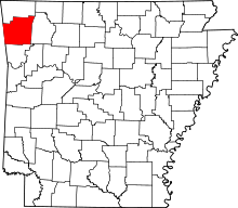
 Brush Creek Township in Washington County, Arkansas | |
| Coordinates: 36°11′30″N 93°57′46″W / 36.19167°N 93.96278°WCoordinates: 36°11′30″N 93°57′46″W / 36.19167°N 93.96278°W | |
| Country |
|
| State |
|
| County | Washington |
| Established | before 1836[1] |
| Area | |
| • Total | 42.7 sq mi (111 km2) |
| • Land | 39.7 sq mi (103 km2) |
| • Water | 3.0 sq mi (8 km2) |
| Elevation | 1,306 ft (398 m) |
| Population (2000) | |
| • Total | 2,216 |
| • Density | 56/sq mi (22/km2) |
| Time zone | CST (UTC-6) |
| • Summer (DST) | CDT (UTC-5) |
| Area code(s) | 479 |
| GNIS feature ID | 69780 |
| U.S. Geological Survey Geographic Names Information System: Brush Creek Township, Washington County, Arkansas | |
Brush Creek Township is one of thirty-seven townships in Washington County, Arkansas, USA.[2] As of the 2000 census, its unincorporated population was 2,216.
Geography
According to the United States Census Bureau, Brush Creek Township covers an area of 39.7 square miles (103 km2) of land and 3.0 square miles (7.8 km2) of water for 42.7 square miles (111 km2) in total area.[2] Brush Creek Township gave some area up to Goshen Township in 1879.[1]
Cities, towns, villages
Cemeteries
The township contains Joyce Cemetery and Morriss Cemetery.
Major routes
 U.S. Route 412
 Arkansas Highway 45 (on township line with Goshen Twp.)
 Arkansas Highway 303
References
- United States Census Bureau 2008 TIGER/Line Shapefiles
- United States Board on Geographic Names (GNIS)
- United States National Atlas
External links
 |
Big Spring Township, Benton County | War Eagle Township, Benton County | California Township, Madison County | |
| Springdale Township | |
Bohannan Township, Madison County | ||
| ||||
| | ||||
| Fayetteville Township | Goshen Township | Bohannan Township, Madison County |
This article is issued from Wikipedia - version of the 11/9/2016. The text is available under the Creative Commons Attribution/Share Alike but additional terms may apply for the media files.