Cova-Ribeira da Torre-Paul Natural Park
| Cova-Ribeira da Torre-Paul Natural Park | |
|---|---|
|
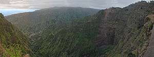
The Paul Valley facing towards the ocean | |
| Area | around 100 km² |
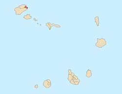
Cova-Ribeira da Torre-Paul Natural Park, in the east of the island of Santo Antão, is one of nine "natural parks" in the country of Cape Verde.[1] The area is around 50 km². The area covers the southeastern part of the municipality of Ribeira Grande, all of Paul and a tiny portion of Porto Novo
About the Natural Park

The natural park includes several geographical features including the Cova Crater, Ribeira da Torre (except for the vicinity of Ribeira Grande) and the Paul Valley which includes the Janela valleys in the east. The park boundaries are marked except for the eastern part where the actual marking is unknown, parts are marked at the Porto Novo municipal boundary.
Other geographical features
Other geographical features as well as notable landmarks in the natural park includes:
- Pico da Cruz
- Topo da Miranda, 2 km east of the right bank of Ribeira da Torre
- Village of Pico da Cruz
- Lombo Branco
- Xoxo
- Portions of Corda
- Ribeirão Fundo - in the municipality of Porto Novo
- Tope Verde
- Farol de Ponta do Tumbo
World Heritage Site elevation plans
A plan to make the nautral park as a World Heritage Site began as a nomination in 2004, one of eight in the tentative list. No plans have been made.
Panoramics
The area offers panoramic views incuding the Ribeira do Paul, Ribeira da Janela, the east of Porto Novo and the south of the island and the island of São Vicente and its surrounding islets.
See also
References
- ↑ Espaços Naturais Protegidos , 2013
Coordinates: 17°07′19″N 25°01′36″W / 17.12208°N 25.02677°W

