Morro, Cape Verde
| Morro | |
|---|---|
| Settlement | |
 Morro | |
| Coordinates: 15°10′48″N 23°13′19″W / 15.180°N 23.222°WCoordinates: 15°10′48″N 23°13′19″W / 15.180°N 23.222°W | |
| Country | Cape Verde |
| Island | Maio |
| Municipality | Maio |
| Civil parish | Nossa Senhora da Luz |
| Population (2010)[1] | |
| • Total | 310 |
Morro (Cape Verdean Creole: Morr) is a settlement in the west of the island of Maio in Cape Verde. It is located 5 km north of the island capital Vila do Maio, it is also south of Calheta. As of the 2010 census, its population was 310.
The settlement is named after its nearby beach which is about 3 kilometers long, the beach forms a part of a nature reserve.[2] Hotels and villas built in the 1990s and 2000s are in several portions of the beach.
Morro has its rock formation, deep inside it consists of sea chalk sediments dating from the Valanginian and Barremian age formed as late as 8 million years ago.[3]
Football (soccer) club includes Morreirense.
See also
References
- ↑ "2010 Census results". Instituto Nacional de Estatística Cabo Verde (in Portuguese). 17 March 2014.
- ↑ areasprotegidas.gov.cv
- ↑ Muller, R. (2008). Age, spreading rates and spreading symmetry of the world’s ocean crust. 9 (Q04006). Geochemistry Geophysics Geosystems. p. 1525-2027.
The island of Maio and the surrounding islands | ||
|---|---|---|
| Communities and settlements | 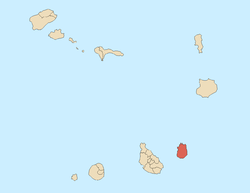 | |
| Parishes | ||
| Mountains | ||
| Other geographical features | ||
This article is issued from Wikipedia - version of the 12/4/2016. The text is available under the Creative Commons Attribution/Share Alike but additional terms may apply for the media files.