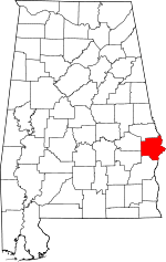
Crawford, Russell County, Alabama
| Crawford, Alabama | |
|---|---|
| Unincorporated community | |
|
Tuckabatcha Masonic Lodge No. 863, taken in 1935 as part of the Historic American Buildings Survey | |
 Crawford, Alabama  Crawford, Alabama | |
| Coordinates: 32°27′25″N 85°11′23″W / 32.45694°N 85.18972°WCoordinates: 32°27′25″N 85°11′23″W / 32.45694°N 85.18972°W | |
| Country | United States |
| State | Alabama |
| County | Russell |
| Elevation | 446 ft (136 m) |
| Time zone | Central (CST) (UTC-6) |
| • Summer (DST) | CDT (UTC-5) |
| Area code(s) | 334 |
| GNIS feature ID | 116821[1] |
Crawford is an unincorporated community in Russell County, Alabama, United States. Crawford is located at the junction of U.S. Route 80 and Alabama State Route 169, 6.5 miles (10.5 km) west of Ladonia. It was the second county seat of Russell County from 1839-1868 before it removed to Seale.[2]
Demographics
| Historical population | |||
|---|---|---|---|
| Census | Pop. | %± | |
| 1860 | 187 | — | |
| 1880 | 124 | — | |
| U.S. Decennial Census[3] | |||
Crawford was listed as an incorporated town on the 1860 U.S. Census when it was the Russell County Seat. It last appeared on the 1880 U.S. Census and has not appeared since.
References
- ↑ "Crawford". Geographic Names Information System. United States Geological Survey.
- ↑ http://www.encyclopediaofalabama.org/article/h-1335
- ↑ "U.S. Decennial Census". Census.gov. Archived from the original on May 11, 2015. Retrieved June 6, 2013.
This article is issued from Wikipedia - version of the 12/2/2016. The text is available under the Creative Commons Attribution/Share Alike but additional terms may apply for the media files.
