Electoral district of South Bourke
| South Bourke Victoria—Legislative Assembly | |
|---|---|
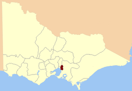 Location in Victoria | |
| State | Victoria |
| Created | 1856 |
| Abolished | 1889 |
| Namesake | Bourke South |
| Demographic | Rural |
For the district of the unicameral Victorian Legislative Council 1851–1856, see Electoral district of South Bourke, Evelyn and Mornington.
The Electoral district of South Bourke (sometimes Bourke South) was an electoral district of the Legislative Assembly in then Australian colony of Victoria.[1] It was one of the original 36 electoral districts of the Assembly.[2] It covered an area east of Melbourne, bounded by Dandenong Creek in the south and east, Moorabbin, Prahran and Hawthorn in the west and Templestowe in the north.[3] It was abolished in 1889.[1]

Electoral districts of West Bourke, East Bourke and South Bourke
Members for South Bourke
Two members originally, one after the redistribution of 1877.[4]
| Member 1 | Term | Member 2 | Term |
|---|---|---|---|
| Patrick O'Brien | Nov. 1856 – Aug. 1859 | Charles Pasley | Nov. 1856 – July 1857[r] |
| Sidney Ricardo | July 1857[b] – Aug. 1859 | ||
| Louis Smith | Oct. 1859 – Dec. 1865 | Hibbert Newton | Oct. 1859 – July 1861 |
| George Paton Smith | Feb. 1866 – Jan. 1871 | Michael O'Grady | Aug. 1861 – May? 1868 |
| James Fergusson | Apr. 1871 – Mar. 1874 | John Crews | May 1868[b] – Apr. 1877 |
| George Paton Smith | May 1874 – Apr. 1877 | ||
| James Fergusson | May 1877 – Feb. 1880 | ||
| John Keys | May 1880 – Mar. 1889 |
r = resigned
b = by election
Keys went on to represent the new Electoral district of Dandenong and Berwick from April 1889.[5]
References
- 1 2 3 "Re-Member (Former Members)". State Government of Victoria. Retrieved 18 May 2013.
- ↑ Edward Sweetman (1920). Constitutional Development of Victoria, 1851-6. Whitcombe & Tombs Limited. p. 182. Retrieved 18 May 2013.
- ↑ "Electoral Districts of West Bourke East Bourke and South Bourke" (map). State Library of Victoria. Retrieved 18 May 2013.
- ↑ "The Elections in Victoria.". The Sydney Morning Herald. Trove. 12 May 1877. Retrieved 24 April 2013.
- ↑ "Keys, John". re-member: a database of all Victorian MPs since 1851. Parliament of Victoria. Retrieved 18 May 2013.
Coordinates: 37°55′S 145°10′E / 37.917°S 145.167°E
This article is issued from Wikipedia - version of the 8/18/2016. The text is available under the Creative Commons Attribution/Share Alike but additional terms may apply for the media files.