Kračali
| Kračali | |
|---|---|
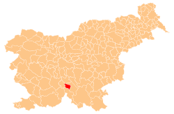
 Kračali Location in Slovenia | |
| Coordinates: 45°45′19.73″N 14°34′50.45″E / 45.7554806°N 14.5806806°ECoordinates: 45°45′19.73″N 14°34′50.45″E / 45.7554806°N 14.5806806°E | |
| Country |
|
| Traditional region | Lower Carniola |
| Statistical region | Southeast Slovenia |
| Municipality | Sodražica |
| Area | |
| • Total | 0.69 km2 (0.27 sq mi) |
| Elevation | 804.3 m (2,638.8 ft) |
| Population (2002) | |
| • Total | 39 |
| [1] | |
Kračali (pronounced [kɾaˈtʃaːli]) is a settlement in the hills west of Sodražica in southern Slovenia. It is included in the Southeast Slovenia Statistical Region. Traditionally the area around Sodražica was part of Lower Carniola.[2] Together with the villages of Betonovo, Janeži, Petrinci, and Kržeti it comprises the community and Parish of Gora nad Sodražico, also known as Gora.[3]
Mass graves
Kračali is the site of three known mass graves or unmarked graves associated with the Second World War. The Kračali 1 Grave (Slovene: Grobišče Kračali 1), also known as the Pasture 1 Grave (Grobišče Planina 1), is located north of the road west of the village. It contains the remains of undetermined victims.[4] The Kračali 2 Grave (Grobišče Kračali 2), also known as the Pasture 2 Grave (Grobišče Planina 2), is located south of the first grave. It contained the remains of an unknown person buried under a tree stump and has probably been exhumed.[5] The Betonovo Grave (Grob Betonovo) is located south of the road. It contained the remains of a Home Guard pilot and was probably exhumed during road construction.[6]
References
- ↑ Statistical Office of the Republic of Slovenia Archived November 18, 2008, at the Wayback Machine.
- ↑ Sodražica municipal site
- ↑ V.P. 1966. "Zakaj pa ne turizem na Gori?" Dolenjski list 17, no. 25 (848) (30 June), p. 14.
- ↑ Kračali 1 Mass on Geopedia (Slovene)
- ↑ Kračali 2 Grave on Geopedia (Slovene)
- ↑ Betonovo Grave on Geopedia (Slovene)
