Palo-Alto
| Palo-Alto Barangay ng Palo-Alto, Lungsod ng Calamba | ||
|---|---|---|
| Upland Barangay | ||
| Barangay Palo-Alto, Calamba City | ||
| ||
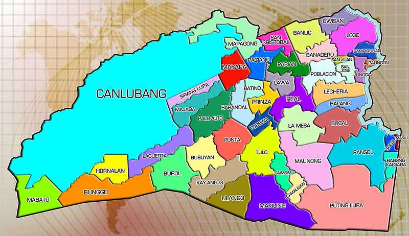
 Map of Calamba City showing the location of the barangays | ||
| Coordinates: 14°11′26″N 121°06′38″E / 14.19056°N 121.11056°ECoordinates: 14°11′26″N 121°06′38″E / 14.19056°N 121.11056°E | ||
| Country | Philippines | |
| Province | Laguna | |
| CALABARZON (Region IV-A) | City | |
| Government | ||
| • Chairman | Geminiano T. Villa Jr, | |
| • Councilors |
| |
| Area | ||
| • Total | 3.76 km2 (1.45 sq mi) | |
Palo-Alto is an upland barangay, is a subdivision project located in Calamba, Laguna in the Philippines, south of Mayapa, west of Barandal, south-east of Majada Out, and northeast of Laguerta. It houses various residential areas such as the Pag-Ibig Project and Koalisyon Pabahay ng Pilipinas.
Geography
Neighboring Barangays:
Sitios and Puroks
- Kaskuhan
- Manggahan
- Compose of 6 Puroks
Villages
- Maresco
- Hacienda Hill
- Bay Hill
- Oak Hill
- Pacific Hill
- Palm Hill
- Southwinds
- Mountain View
- High Lands
Demography
- 2010 – 10,628
- 2007 – 7,270
- 2000 – 2,881
- 1995 – 2,312
- 1990 – 1,913
- 1980 – 1,472
Geography
Location:
- Palo-Alto, Calamba City
 |
Majada Out | Mayapa |  | |
| Laguerta | |
Barandal | ||
| ||||
| | ||||
| Bubuyan | Punta |
References
External links
This article is issued from Wikipedia - version of the 12/3/2016. The text is available under the Creative Commons Attribution/Share Alike but additional terms may apply for the media files.
