Sal, Cape Verde (municipality)
| Sal | ||
|---|---|---|
| Municipality | ||
| ||
 | ||
| Coordinates: 16°44′N 22°56′W / 16.73°N 22.93°WCoordinates: 16°44′N 22°56′W / 16.73°N 22.93°W | ||
| Country | Cape Verde | |
| Island | Sal | |
| Area | ||
| • Total | 219.8 km2 (84.9 sq mi) | |
| Population (2010)[1] | ||
| • Total | 25,481 | |
| • Density | 120/km2 (300/sq mi) | |
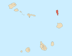
Sal is a concelho (municipality) of Cape Verde. It covers the whole island of Sal. Its capital is the town Espargos. The municipality consists of one freguesia (civil parish), Nossa Senhora das Dores, which also covers the whole island. The freguesia is subdivided into the following settlements:
Economy
Sal’s main town, Espargos, is home to one of the nation’s international airports and has around 17,000 inhabitants. Sal's population grew around salt collection and later shifted to fishing, but is now based on tourism (amounting to 50% of the archipelago’s tourism) at the beach resort of Santa Maria.
Its airport, Amílcar Cabral International Airport, was used as a refuelling base by South African Airways on its Johannesburg to London routes. Later, flights to and from New York City and Atlanta also refuelled there, and the island was a crew-change station. SAA established the long runways needed by the fully fueled Boeing 707s on their take-offs in the high temperatures. On July 1, 2006, SAA operated its final flight to Sal due to the ending of its flights to Atlanta.
Saline marshes can be found in the Pedra de Lume crater and north of Santa Maria.
Transportation
The major roads on the island are:
- Santa Maria - Espargos Road (paved)
- Palmeira - Espargos Road (narrowly paved)
- Pedra de Lume - Espargos Road (paved)
- Espargos - Reguinho Fiúra Road (unpaved)
Settlements
There are six inhabited centers:
- Pedra de Lume, on the eastern coast, is the most ancient, and the home of the first salt workers. Today it is only a small village with very few inhabitants.
- Palmeira is a fishing village, built around a port situated on the opposite coast of the island. It is also a small village but is growing.
- Espargos is the main urban center and is situated between Pedra de Lume and Palmeira. It was formed around the international airport named after Amílcar Cabral (IATA airport code SID) located in the heart of the island.
- Terra Boa is the only place on the island where agriculture can be found on a large scale, as the island is very dry, mainly because it has no mountains to induce rainfall. This place is situated north of Espargos.
- Murdeira is a tourist resort, which is growing in population.
- Santa Maria, which was a former salt working village, is now the tourism center of the island.
Other inhabited settlements are:
- Feijoal, 1 km west of Pedra de Lume.
- Fontona, south of Palmeira.
- Reguinho Fiúra, a remote village near a lighthouse and overlooking Ponta Norte, the island's northernmost point.
History
It was created in 1935, when, due to a population increase, it was separated from the older Municipality of Boa Vista.
Demography
| Population of Sal, Cape Verde (municipality) (1940—2010) | |||||||
|---|---|---|---|---|---|---|---|
| 1940[2] | 1950[2] | 1960[2] | 1970[2] | 1980[2] | 1990[2] | 2000[3] | 2010[4] |
| 1121 | 1838 | 2608 | 5505 | 5826 | 7715 | 14816 | 25481 |
References
- ↑ "2010 Census results". Instituto Nacional de Estatística Cabo Verde (in Portuguese). 17 March 2014.
- 1 2 3 4 5 6 Source: Statoids
- ↑ Source: Instituto Nacional de Estatísticas.
- ↑ "2010 Census results Sal". Instituto Nacional de Estatística Cabo Verde (in Portuguese). 19 March 2014.
