Warren, Arkansas
| Warren, Arkansas | |
|---|---|
| City | |
|
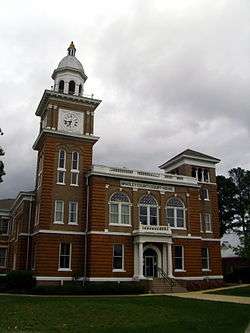
Bradley County Courthouse and Clerk's Office in downtown Warren | |
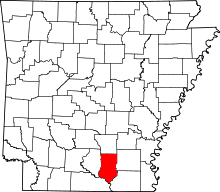
 Location of Warren, Arkansas | |
| Coordinates: 33°36′37″N 92°4′11″W / 33.61028°N 92.06972°WCoordinates: 33°36′37″N 92°4′11″W / 33.61028°N 92.06972°W | |
| Country | United States |
| State | Arkansas |
| County | Bradley |
| Area | |
| • Total | 7.24 sq mi (18.74 km2) |
| • Land | 7.21 sq mi (18.68 km2) |
| • Water | 0.02 sq mi (0.06 km2) |
| Elevation | 220 ft (67 m) |
| Population (2010) | |
| • Total | 6,003 |
| • Density | 832/sq mi (321.4/km2) |
| Time zone | Central (CST) (UTC-6) |
| • Summer (DST) | CDT (UTC-5) |
| ZIP code | 71671 |
| Area code(s) | 870 |
| FIPS code | 05-73310 |
| GNIS feature ID | 0078699 |
Warren is a city in and the county seat of Bradley County, Arkansas, United States.[1] As of the 2010 census, the population was 6,003.[2]
History
When settlers from the east began to arrive in south Arkansas, the land was inhabited by the indigenous tribe known as the Quapaw. The earliest cession of territory was made in 1818, with a later boundary against the neighboring Choctaw tribe in 1820, opening up the southeastern corner of the Arkansas Territory for settlement. Although the area had been settled by European-Americans for about thirty years, the city itself was not incorporated until 1851. Tradition says the city is named after a former slave, freed by Captain Hugh Bradley, the namesake of the county and leader of the main early settlement party which established the city. The original plat was laid out on land donated by Isaac Pennington, a key member of Bradley's company.
Around the turn of the twentieth century, Warren found itself in the middle of a boom in the timber industry, a resource which continues to be important to the city's economy, although the lumber yards that were vital to Warren throughout the past century are no longer in operation.
The city's Victorian-era courthouse was originally built in 1903 and still maintains the exterior character, despite necessary refurbishments to the interior offices and courtroom.
Geography
Warren is located in northeast Bradley County on high ground 2 miles (3 km) west of the Saline River, a tributary of the Ouachita River. U.S. Route 63 passes through the center of the city, leading north 46 miles (74 km) to Pine Bluff and southwest 50 miles (80 km) to El Dorado. U.S. Route 278 bypasses Warren to the south and leads east 16 miles (26 km) to Monticello and west 26 miles (42 km) to Hampton.
According to the United States Census Bureau, Warren has a total area of 7.2 square miles (18.7 km2), of which 0.023 square miles (0.06 km2), or 0.33%, is water.[2]
Climate
The climate in this area is characterized by hot, humid summers and generally mild to cool winters. According to the Köppen Climate Classification system, Warren has a humid subtropical climate, abbreviated "Cfa" on climate maps.[3] Tornadoes have occurred on at least two occasions. The first occurred on January 3, 1949, killing 55 people and injuring 435. On March 28, 1975, another tornado killed 7 people and injured 51.[4] Both were rated F4 on the Fujita scale.[5]
Arts and culture
Annual cultural events
The Bradley County Pink Tomato Festival is held yearly in Warren, normally the second week of June. Begun in 1956, the festival is one of Arkansas' longest-running annual community festivals. Organized by the Bradley County Chamber of Commerce, the festival celebrates the South Arkansas Vine Ripe Pink Tomato, a special variety of tomato which holds the distinction of being Arkansas' state fruit and state vegetable. The festival has a tradition of being well-planned, with such activities as tomato-eating contests and street dances, the atmosphere of which benefit greatly from the layout of broad brick-paved streets around the courthouse square.
Education
Public education for early childhood, elementary and secondary school students is provided by Warren School District.
Warren High School's athletic emblem and mascot is The Fightin' Lumberjacks. (The Junior High sports teams are known as the Jr. Jacks, and the cheerleading squad is known as the Jumpin' Jacks.) The school colors are orange and black. The Lumberjack football team won the Class AAA State Championship in 2001, 2002, and Class 4A Championship in 2014. They were also the 2006 and 2013 Class 4A State Runner-up in Football. The Lumberjack baseball team were the Class AAA State Champions in 2005. After the 2015 football season, the school district announced that synthetic turf would replace the natural grass field at Jim Hurley Jr Stadium. It is scheduled to be completed in the summer of 2016. With a traditional powerhouse football team and growing soccer program, Lumberjack field will be a premiere venue in southeast Arkansas.
Demographics
| Historical population | |||
|---|---|---|---|
| Census | Pop. | %± | |
| 1880 | 301 | — | |
| 1890 | 492 | 63.5% | |
| 1900 | 954 | 93.9% | |
| 1910 | 2,057 | 115.6% | |
| 1920 | 2,145 | 4.3% | |
| 1930 | 2,523 | 17.6% | |
| 1940 | 2,516 | −0.3% | |
| 1950 | 2,615 | 3.9% | |
| 1960 | 6,752 | 158.2% | |
| 1970 | 6,433 | −4.7% | |
| 1980 | 7,646 | 18.9% | |
| 1990 | 6,455 | −15.6% | |
| 2000 | 6,442 | −0.2% | |
| 2010 | 6,003 | −6.8% | |
| Est. 2015 | 5,804 | [6] | −3.3% |
As of the census[8] of 2000, the racial makeup of the city was 52.46% White, 46.79% Black or African American, 0.19% Native American, 0.08% Asian, 0.02% Pacific Islander, 3.82% from other races, and 0.65% from two or more races. 5.08% of the population were Hispanic or Latino of any race.
Out of households reporting, 29.0% had children under the age of 18 living with them, 44.6% were married couples living together, 17.9% had a female householder with no husband present, and 34.1% were non-families. 31.4% of all households were made up of individuals and 15.6% had someone living alone who was 65 years of age or older. The average household size was 2.36 and the average family size was 2.96.
In the city the population was spread out with 24.0% under the age of 18, 9.0% from 18 to 24, 24.8% from 25 to 44, 21.5% from 45 to 64, and 20.8% who were 65 years of age or older. The median age was 39 years. For every 100 females there were 84.7 males. For every 100 females age 18 and over, there were 80.6 males.
The median income for a household in the city was $22,162, and the median income for a family was $27,618. Males had a median income of $27,778 versus $17,247 for females. The per capita income for the city was $13,453. About 24.3% of families and 28.7% of the population were below the poverty line, including 37.4% of those under age 18 and 23.9% of those age 65 or over.
Notable people
- Greg Childs, NFL player, wide receiver for the Minnesota Vikings
- Maud Crawford, missing attorney from Camden, Arkansas, who disappeared in 1957, was reared in Warren and graduated in 1911 from Warren High School.[9]
- James T. Draper, Sr., Southern Baptist pastor in Warren in the early 1960s
- Chris Gragg, NFL player, tight end for the Buffalo Bills
- Jarius Wright, NFL player, wide receiver for the Minnesota Vikings
- Chester Turner, American serial killer
See also
-
 Arkansas portal
References
- ↑ "Find a County". National Association of Counties. Retrieved 2011-06-07.
- 1 2 "Geographic Identifiers: 2010 Demographic Profile Data (G001): Warren city, Arkansas". U.S. Census Bureau, American Factfinder. Retrieved September 25, 2013.
- ↑ Climate Summary for Warren, Arkansas
- ↑ http://www.tornadoproject.com/alltorns/worstts.htm
- ↑ http://www.ericsweatherlibrary.com/f4f5/
- ↑ "Annual Estimates of the Resident Population for Incorporated Places: April 1, 2010 to July 1, 2015". Retrieved July 2, 2016.
- ↑ "Census of Population and Housing". Census.gov. Retrieved June 4, 2015.
- ↑ "American FactFinder". United States Census Bureau. Retrieved 2008-01-31.
- ↑ "Maud Robinson Crawford (1891-1957)". encyclopediaofarkansas.net. Retrieved January 14, 2011.

